Mobility Risk

Visualization of a Planet in Lockdown

Visualization of a Planet in Lockdown

We visualize global mobility patterns over a full year of pandemic induced lockdowns

Reading Time: 5 min.
Visualizing a year in lockdowns and restricted mobility 
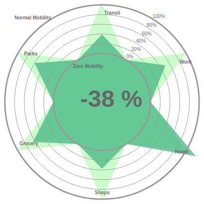
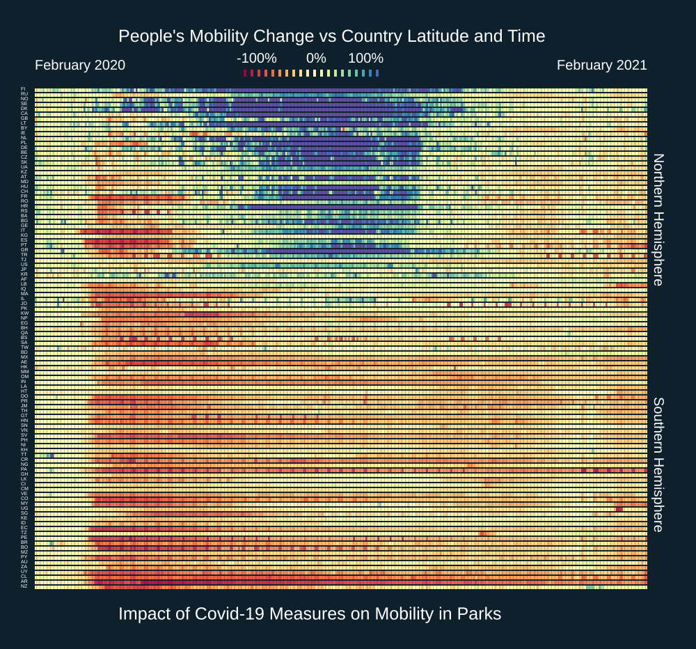
As we move into February 2021 the world will be experiencing almost a year under pandemic conditions. This has markedly changed behavioral patterns of human mobility across the board. One major difference with previous pandemics is that through the use of a variety of digital technologies and new data collection channels we know have an unprecedented view of those changing mobility patterns.
A Global Mobility Index

A Global Mobility Index

We introduce a global mobility index that averages Google mobility data across all available countries (weighting by population) to provide an overall view of how the pandemic has influenced human mobility

Reading Time: 6 min.
Constructing a Global Mobility Index (GMI) In previous posts (here, and here) we introduced new Open Risk Dashboard functionalities that integrate COVID-19 community mobility data (currently focusing on the datasets provided by Google). As a reminder, these reports chart over time human mobility trends collected from mobile geolocation data. The granularity is by geography and across different categories of places / activities such as retail and recreation areas, groceries and pharmacies, parks, transit stations, workplaces, and residential areas.
Comparing Google Community Mobility Reports Across Countries

Comparing Google Community Mobility Reports Across Countries

Reading Time: 5 min.
The community mobility reports and OpenCPM In a previous post we introduced new OpenCPM functionality that integrates COVID-19 community mobility data (currently from Google). The reports chart movement trends over time by geography, across different categories of places such as retail and recreation, groceries and pharmacies, parks, transit stations, workplaces, and residential. While these reports are unlikely to persist as open data sources in the long term, the current availability (as of May 2020) enables providing within OpenCPM a mobility data dashboard that can help draw insights through visualization and statistical analysis.
Exploring Community Mobility Reports Using OpenCPM

Exploring Community Mobility Reports Using OpenCPM

Reading Time: 7 min.
The community mobility reports and OpenCPM As the COVID-19 pandemic unfolded technology providers (most notably Google and Apple) made available to the public aggregated and anonymized data about human mobility in the crisis period (on the basis of smartphone location data). These Community Mobility Reports provide insights into how mobility patterns changed in response both to pandemic news and policies aimed at combating COVID-19. The reports chart movement trends over time by geography, across different categories of locations and activities, such as retail and recreation, groceries and pharmacies, parks, transit stations, workplaces, and residential.